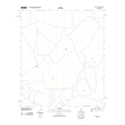
2010 Map of Cave Mesa
USGS Topo · Published 2010About this map
Burnt House Creek defines the drainage of this arid landscape, winding through the north and west of this 2010 survey. The terrain is characterized by high plateaus and isolated peaks, notably the prominent Cave Mesa, Pine Mesa, and Panther Mesa in the southern and eastern reaches. These landforms rise above the surrounding flats, punctuated by North Mountain and the steep walls of Burnt House Canyon. Settlement is sparse, represented primarily by a network of ranch roads and specialized water sources critical for life and livestock in this environment. Several of these small impoundments are identified across the sheet, including Rooney Tank, Hackberry Tank, Witcher Tank, and North Tank. The distribution of these features reveals a geography where water management and the natural contours of the mesas dictate the patterns of human use and movement.
Find a feature on this map
11 named features on this map. Tap any name to fly to it.
Don’t see what you’re looking for? This feature index may not catch every label — zoom into the map to look around manually.
Map Details
Editions of this 2010 Cave Mesa Map
This is the sole edition of this map. No revisions or reprints were ever made.
Other maps of this area

1923 · Hess Canyon
USGS Topo · 1:62,500

1923 · Altuda
USGS Topo · 1:62,500

1929 · Hovey
USGS Topo · 1:125,000

1954 · Fort Stockton
USGS Topo · 1:250,000

1958 · Fort Stockton
USGS Topo · 1:250,000

1973 · Fort Stockton
USGS Topo · 1:250,000
1980 · Chancellor
USGS Topo · 1:24,000
1980 · Cave Mesa NE
USGS Topo · 1:24,000

1980 · Cave Mesa
USGS Topo · 1:24,000

1980 · Hovey
USGS Topo · 1:24,000