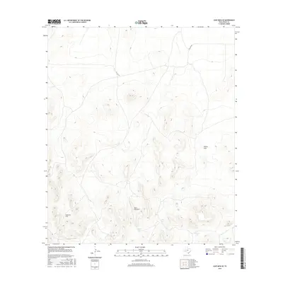
2016 Map of Cave Mesa SE
USGS Topo · Published 2016About this map
The Glass Mountains dominate this West Texas landscape, showing the dramatic topography of Pecos County in the mid-2010s. This survey records a high-desert environment defined by complex elevation changes rather than dense human settlement. Water management is the primary evidence of land use, with features such as Wade Tank, Hill Tank, and Granger Tank strategically placed to collect runoff in an arid climate. These artificial catchments are vital markers for those studying cattle ranching history and local land management in this portion of the Trans-Pecos region. Natural drainage patterns are clearly delineated through Belding Draw and Acebuche Draw, which cut through the mountain slopes. Transportation is limited to remote corridors like Esca Lera Rd, providing a clear view of how isolation and topography have preserved the character of this mountain range.
Find a feature on this map
7 named features on this map. Tap any name to fly to it.
Don’t see what you’re looking for? This feature index may not catch every label — zoom into the map to look around manually.
Map Details
Editions of this 2016 Cave Mesa SE Map
This is the sole edition of this map. No revisions or reprints were ever made.
Other maps of this area

1920 · Longfellow
USGS Topo · 1:125,000

1923 · Hess Canyon
USGS Topo · 1:62,500

1923 · Sierra Madera
USGS Topo · 1:62,500

1928 · Comanche Spring
USGS Topo · 1:125,000

1929 · Hovey
USGS Topo · 1:125,000

1954 · Fort Stockton
USGS Topo · 1:250,000

1958 · Fort Stockton
USGS Topo · 1:250,000

1968 · Marathon Gap
USGS Topo · 1:24,000

1973 · Fort Stockton
USGS Topo · 1:250,000
1980 · Chancellor
USGS Topo · 1:24,000