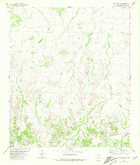
1980 Map of Cave Mesa SE
USGS Topo · Published 1981About this map
Arid canyonlands and desert drainage systems characterize this Pecos County landscape as it was documented in the mid-1970s. The terrain is defined by two primary watercourses, Acebuche Draw and Belding Draw, which cut through the high mesa country and serve as the principal topographic anchors for the region. These ephemeral channels provided critical drainage in an environment where water management was paramount for ranching and local operations. Evidence of human infrastructure is sparse but functional, centered on isolated water catchments such as Wade Tank and Granger Tank. A remote Landing Strip in the southern portion of the quadrangle suggests the logistical challenges of accessing this high-elevation terrain. This survey captures a moment of quiet utility in West Texas, where the land is marked primarily by these vital water features and the occasional industrial footprint of a Gravel Pit.
Find a feature on this map
6 named features on this map. Tap any name to fly to it.
Don’t see what you’re looking for? This feature index may not catch every label — zoom into the map to look around manually.
Map Details
Editions of this 1980 Cave Mesa SE Map
This is the sole edition of this map. No revisions or reprints were ever made.
Other maps of this area

1920 · Longfellow
USGS Topo · 1:125,000

1923 · Hess Canyon
USGS Topo · 1:62,500

1923 · Sierra Madera
USGS Topo · 1:62,500

1928 · Comanche Spring
USGS Topo · 1:125,000

1929 · Hovey
USGS Topo · 1:125,000

1954 · Fort Stockton
USGS Topo · 1:250,000

1958 · Fort Stockton
USGS Topo · 1:250,000

1968 · Marathon Gap
USGS Topo · 1:24,000

1973 · Fort Stockton
USGS Topo · 1:250,000
1980 · Chancellor
USGS Topo · 1:24,000