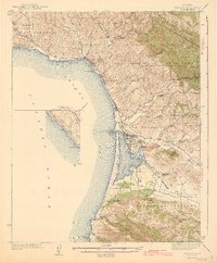
1943 Map of Cayucos
USGS Topo · Published 1943About this map
Morro Rock stands as a landmark sentinel along the central California coast, marking the entrance to the natural harbor of Morro Bay. Surveyed in the late 1930s, this landscape shows the rural distribution of several early educational centers, including Squire Sch and Central Sch in the north, and Sunnyside Sch and Los Osos Sch further south. The coastline transitions from the high peaks of the San Luis Range and Valencia Peak in the south, past the sheltered waters of the bay, to the seaside settlement of Cayucos and the dramatic Point Estero. Inland, the geography is defined by broad valleys and scattered ranch lands, where the Los Osos Valley and Cañada de los Osos y Pecho y Islay separate the rugged coastal ridges. The survey captures a moment before modern suburbanization, with small clusters like Morro Beach and Redfield Woods beginning to take shape along State Highway No 1.
Find a feature on this map
48 named features on this map. Tap any name to fly to it.
Don’t see what you’re looking for? This feature index may not catch every label — zoom into the map to look around manually.
Map Details
Editions of this 1943 Cayucos Map
2 editions found

Other maps of this area

1897 · Port Harford
USGS Topo · 1:62,500

1897 · San Luis Obispo
USGS Topo · 1:62,500

1897 · Cayucos
USGS Topo · 1:62,500

1897 · Arroyo Grande
USGS Topo · 1:62,500

1900 · San Luis
USGS Topo · 1:125,000

1919 · Paso Robles
USGS Topo · 1:62,500

1919 · Adelaida
USGS Topo · 1:62,500

1919 · San Simeon
USGS Topo · 1:62,500

1932 · Adelaida
USGS Topo · 1:62,500

1937 · Cayucos
USGS Topo · 1:62,500