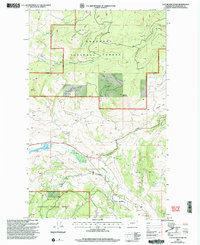
2001 Map of Cayuse Mountain
USGS Topo · Published 2004About this map
Cayuse Mountain and Island Mountain dominate this landscape within the Okanogan National Forest, where a complex network of forest roads and 4WD tracks provides access to the high country. The area is defined by its drainages, with Bonaparte Creek cutting through the central terrain and the Aeneas Valley opening to the southeast. Land use is evidenced by several Gravel Pits and a dedicated Landing Strip, suggesting a mix of resource management and local aviation. The map also delineates several Indian Allotment Boundaries and the broader Forest Boundary, reflecting the jurisdictional history of the region. Numerous named water sources, including Fourth of July Creek and North Fork Siwash Creek, trace the complex topography of the Okanogan highlands during the early 21st century.
Find a feature on this map
22 named features on this map. Tap any name to fly to it.
Don’t see what you’re looking for? This feature index may not catch every label — zoom into the map to look around manually.
Map Details
Editions of this 2001 Cayuse Mountain Map
This is the sole edition of this map. No revisions or reprints were ever made.
Other maps of this area

1902 · Osoyoos
USGS Topo · 1:125,000

1904 · Osoyoos
USGS Topo · 1:125,000

1954 · Okanogan
USGS Topo · 1:250,000

1957 · Mt. Bonaparte
USGS Topo · 1:62,500

1957 · Tonasket
USGS Topo · 1:62,500

1957 · Oroville
USGS Topo · 1:62,500

1957 · Aeneas Valley
USGS Topo · 1:62,500

1958 · Okanogan
USGS Topo · 1:250,000
1981 · Barker Mtn
USGS Topo · 1:24,000
1981 · Burge Mtn
USGS Topo · 1:24,000