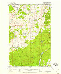
1957 Map of Mt. Bonaparte
USGS Topo · Published 1958About this map
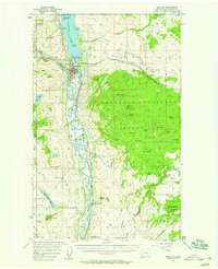
The International Boundary defines the northern edge of this high-country survey, where the rugged topography of the Okanogan National Forest meets the scattered agricultural settlements of northern Washington. The map highlights the transition from mining and ranching hubs like Chesaw and the Bolster (Site) to the dense timberland of the national forest. Evidence of the region’s hard-rock mining history is anchored by the Poland China Mine near Molson Hill, while the presence of the Knobhill Grange and multiple mountain lookouts, including Mt Bonaparte Lookout, underscores a landscape of remote lookouts and community resilience. The area is dotted with numerous small alpine lakes, such as Strawberry Lake and Lost Lake, which serve as focal points for recreation and resource management alongside established sites like Camp Ortoha and the Boy Scout Camp.
Find a feature on this map
77 named features on this map. Tap any name to fly to it.
Don’t see what you’re looking for? This feature index may not catch every label — zoom into the map to look around manually.
Map Details
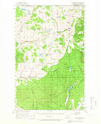
Editions of this 1957 Mt. Bonaparte Map
2 editions found
Other maps of this area

1902 · Osoyoos
USGS Topo · 1:125,000

1904 · Osoyoos
USGS Topo · 1:125,000

1904 · Republic
USGS Topo · 1:125,000
1951 · Wauconda
USGS Topo · 1:62,500

1951 · Bodie Mountain
USGS Topo · 1:62,500

1954 · Okanogan
USGS Topo · 1:250,000
1957 · Tonasket
USGS Topo · 1:62,500
1957 · Oroville
USGS Topo · 1:62,500
1957 · Aeneas Valley
USGS Topo · 1:62,500

1958 · Okanogan
USGS Topo · 1:250,000