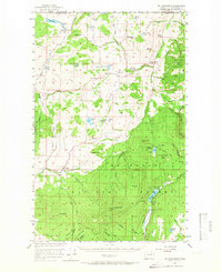
1957 Map of Mt. Bonaparte
USGS Topo · Published 1966About this map
The high plateau and mountain peaks of Okanogan National Forest dominate this mid-century survey along the international boundary. The terrain is marked by the distinct summits of Mt Bonaparte and Bimetalic Mtn, illustrating the region's complex topography south of the British Columbia border. Hardrock mining history is evident through the presence of the Poland China Mine and the Bimetalic Mine, while small settlements like Chesaw and Molson serve as focal points for the agricultural and ranching valleys of Eden Valley and Hungry Hollow. The map also captures the recreational character of the era, noting local youth sites such as Camp Tokiwanee and Camp Ortoha near Lost Lake, and the Strawberry Mtn Lookout which once stood watch over the surrounding timberlands.
Find a feature on this map
69 named features on this map. Tap any name to fly to it.
Don’t see what you’re looking for? This feature index may not catch every label — zoom into the map to look around manually.
Map Details
Editions of this 1957 Mt. Bonaparte Map
2 editions found
Other maps of this area

1902 · Osoyoos
USGS Topo · 1:125,000

1904 · Osoyoos
USGS Topo · 1:125,000

1904 · Republic
USGS Topo · 1:125,000

1951 · Wauconda
USGS Topo · 1:62,500

1951 · Bodie Mountain
USGS Topo · 1:62,500

1954 · Okanogan
USGS Topo · 1:250,000

1957 · Mt. Bonaparte
USGS Topo · 1:62,500

1957 · Tonasket
USGS Topo · 1:62,500

1957 · Oroville
USGS Topo · 1:62,500

1957 · Aeneas Valley
USGS Topo · 1:62,500