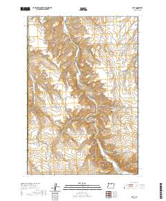
2020 Map of Cecil
USGS Topo · Published 2020About this map
Willow Cr carves a deep path through this portion of the Columbia Plateau, defining the settlement patterns of Cecil and Morgan. This landscape is characterized by a complex network of drainage systems, including Schoolhouse Canyon, Fourmile Canyon, and Morgan Canyon, which reveal the erosional history of the Morrow and Gilliam county line. Local history is anchored at the Morgan Cem and the distinctive geological formation at Horseshoe Bend. The presence of Immigrant Ln and Johnson Grade Ln speaks to the early transportation corridors that followed the natural contours of the terrain. To the south, the elevation rises toward Saddle Butte, marking a transition from the canyon floor to the higher plateaus of central Oregon.
Find a feature on this map
31 named features on this map. Tap any name to fly to it.
Don’t see what you’re looking for? This feature index may not catch every label — zoom into the map to look around manually.
Map Details
Editions of this 2020 Cecil Map
This is the sole edition of this map. No revisions or reprints were ever made.
Other maps of this area

1906 · Blalock Island
USGS Topo · 1:125,000

1908 · Blalock Island
USGS Topo · 1:125,000

1916 · Arlington
USGS Topo · 1:125,000

1916 · Condon
USGS Topo · 1:125,000

1953 · Pendleton
USGS Topo · 1:250,000

1953 · The Dalles
USGS Topo · 1:250,000

1956 · The Dalles
USGS Topo · 1:250,000

1956 · Pendleton
USGS Topo · 1:250,000

1957 · The Dalles
USGS Topo · 1:250,000

1964 · Hickland Butte
USGS Topo · 1:24,000