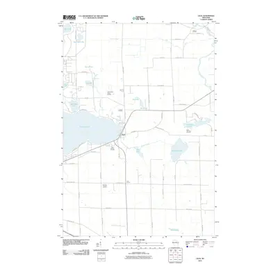
2010 Map of Cecil
USGS Topo · Published 2010About this map
Cecil sits at the junction of waterways and local travel routes, serving as a hub for the surrounding dairy lands and lakefront properties of Shawano County. The landscape is defined by the massive eastern reach of Shawano Lake, which transitions into a complex system of smaller water bodies including White Clay Lake and the Pensaukee Lakes. This 2010 survey illustrates the area's rural character, where the grid of county highways like County Hwy R and County Hwy V connects scattered settlements such as Tracy Corners with local landmarks like the Deer Haven Ranch Airport. Genealogists will find a high density of rural burial grounds preserved across the landscape, from the Saint Paul Lutheran Cemetery in the south to the Underhill Cemetery near the Oconto River in the northeast. The drainage patterns of the West Branch Shloc River and Duchess Creek reveal the subtle elevation changes that define this region of Wisconsin.
Find a feature on this map
65 named features on this map. Tap any name to fly to it.
Don’t see what you’re looking for? This feature index may not catch every label — zoom into the map to look around manually.
Map Details
Editions of this 2010 Cecil Map
This is the sole edition of this map. No revisions or reprints were ever made.
Other maps of this area

1954 · Shawano
USGS Topo · 1:48,000

1955 · Embarrass
USGS Topo · 1:48,000

1955 · Seymour
USGS Topo · 1:62,500

1955 · Green Bay
USGS Topo · 1:250,000

1956 · Gillett
USGS Topo · 1:62,500

1964 · Shawano
USGS Topo · 1:62,500

1969 · Lunds
USGS Topo · 1:24,000

1974 · Cecil
USGS Topo · 1:24,000
1974 · Gillett
USGS Topo · 1:24,000
1974 · Berry Lake
USGS Topo · 1:24,000