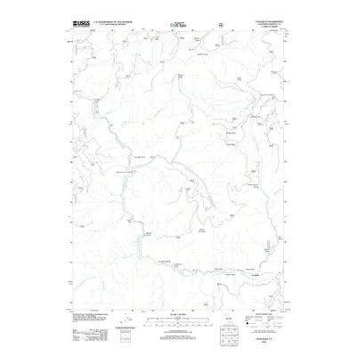
2012 Map of Cecilville
USGS Topo · Published 2012About this map
The S Fork Salmon River carves through the Klamath National Forest area, anchoring the small settlement of Cecilville. This remote mountainous terrain is defined by a deep network of gulches and creeks, including Matthews Cr and French Cr, which historically supported mining and ranching activity. Notable points of interest include Blue Ridge Ranch in the north and the curious naming of Yoakumville and Cody Bar along the waterways. The landscape is marked by significant elevations like Canyon Mountain and Lafayette Point, while the narrow canyon floors provide space for the Matthews Creek Campground and Bacon Rind Campground. Transportation is limited to rugged routes such as Eddy Gulch Rd and Cecilville Rd, reflecting the isolation of this high-elevation Siskiyou County territory.
Find a feature on this map
47 named features on this map. Tap any name to fly to it.
Don’t see what you’re looking for? This feature index may not catch every label — zoom into the map to look around manually.
Map Details
Editions of this 2012 Cecilville Map
This is the sole edition of this map. No revisions or reprints were ever made.
Other maps of this area

1948 · Weed
USGS Topo · 1:250,000

1950 · Weed
USGS Topo · 1:250,000

1955 · Salmon Mtn
USGS Topo · 1:62,500

1955 · Cecilville
USGS Topo · 1:62,500

1955 · Sawyers Bar
USGS Topo · 1:62,500

1955 · Forks of Salmon
USGS Topo · 1:62,500

1958 · Weed
USGS Topo · 1:250,000

1963 · Weed
USGS Topo · 1:250,000
1977 · Tanners Peak
USGS Topo · 1:24,000
1978 · Cecilville
USGS Topo · 1:24,000