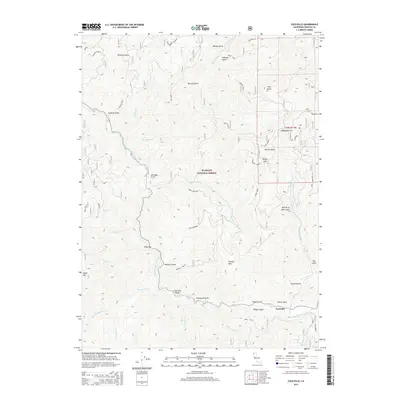
2015 Map of Cecilville
USGS Topo · Published 2015About this map
The settlement of Cecilville serves as the focal point for this 2015 study of the rugged Salmon River country within the Klamath National Forest. The landscape is dominated by the steep drainages of the South Fork Salmon River, where numerous named gulches and creeks such as Matthews Cr, French Cr, and Plummer Cr converge. Historic activity in the region is evidenced by named riverside locations like Cody Bar and the distinctive Limestone Bluffs situated just west of the main settlement. Topographical landmarks define the horizon, including High Point, Lafayette Point, and the prominent Murphy Rock. The map traces a network of remote forest routes, including the King Solomon and Saint Clair roads, illustrating the modern access points to this historically isolated part of Siskiyou County.
Find a feature on this map
61 named features on this map. Tap any name to fly to it.
Don’t see what you’re looking for? This feature index may not catch every label — zoom into the map to look around manually.
Map Details
Editions of this 2015 Cecilville Map
This is the sole edition of this map. No revisions or reprints were ever made.
Other maps of this area

1948 · Weed
USGS Topo · 1:250,000

1950 · Weed
USGS Topo · 1:250,000

1955 · Salmon Mtn
USGS Topo · 1:62,500

1955 · Cecilville
USGS Topo · 1:62,500

1955 · Sawyers Bar
USGS Topo · 1:62,500

1955 · Forks of Salmon
USGS Topo · 1:62,500

1958 · Weed
USGS Topo · 1:250,000

1963 · Weed
USGS Topo · 1:250,000
1977 · Tanners Peak
USGS Topo · 1:24,000
1978 · Cecilville
USGS Topo · 1:24,000