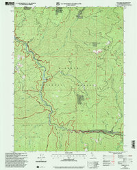
2001 Map of Cecilville
USGS Topo · Published 2004About this map
Cecilville sits at the confluence of the South Fork Salmon River and several mountain drainages, serving as a hub for this remote mining and ranching region of Siskiyou County. The landscape is heavily defined by the legacy of resource extraction, with operations like the King Solomon Mine, Starveout Mine, and Gunbarrel Mine scattered across the steep terrain. These sites, along with smaller claims simply marked Prospect or Prospects, reflect the late 20th-century character of the area where historical mining activity persisted within the protected bounds of the Klamath National Forest.
Find a feature on this map
51 named features on this map. Tap any name to fly to it.
Don’t see what you’re looking for? This feature index may not catch every label — zoom into the map to look around manually.
Map Details
Editions of this 2001 Cecilville Map
This is the sole edition of this map. No revisions or reprints were ever made.
Other maps of this area

1948 · Weed
USGS Topo · 1:250,000

1950 · Weed
USGS Topo · 1:250,000

1955 · Salmon Mtn
USGS Topo · 1:62,500

1955 · Cecilville
USGS Topo · 1:62,500

1955 · Sawyers Bar
USGS Topo · 1:62,500

1955 · Forks of Salmon
USGS Topo · 1:62,500

1958 · Weed
USGS Topo · 1:250,000

1963 · Weed
USGS Topo · 1:250,000
1977 · Tanners Peak
USGS Topo · 1:24,000
1978 · Cecilville
USGS Topo · 1:24,000