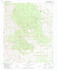
1980 Map of Cedar Basin
USGS Topo · Published 1980About this map
The Aquarius Mountains dominate this high-desert landscape in Mohave County, where water sources dictated the patterns of ranching and movement. The map records a network of vital springs such as Cottonwood Spring, Sam Spring, and Blue Spring that supported seasonal activity. Cattle ranching infrastructure is evident through numerous scattered labels for corral sites and family-named landmarks like Sunburn Windmill and High-Lonesome Windmill. To the south, the terrain levels out onto the expansive Goodwin Mesa and drops away at the Aquarius Cliffs. Settlement is sparse, represented primarily by the Cedar Basin Camp, while evidence of mineral exploration appears in the form of several isolated prospects. The presence of a jeep trail and pack trail suggests the limited accessibility of the canyons and washes, including Bull Canyon and Boner Canyon, which carve through the volcanic and sedimentary geology of the range.
Find a feature on this map
36 named features on this map. Tap any name to fly to it.
Don’t see what you’re looking for? This feature index may not catch every label — zoom into the map to look around manually.
Map Details
Editions of this 1980 Cedar Basin Map
This is the sole edition of this map. No revisions or reprints were ever made.
Other maps of this area

1923 · Signal
USGS Topo · 1:250,000

1942 · Signal
USGS Topo · 1:250,000

1950 · Prescott
USGS Topo · 1:250,000

1954 · Prescott
USGS Topo · 1:250,000

1958 · Prescott
USGS Topo · 1:250,000

1959 · Prescott
USGS Topo · 1:250,000

1960 · Prescott
USGS Topo · 1:250,000

1965 · Prescott
USGS Topo · 1:250,000
1967 · Tom Brown Canyon
USGS Topo · 1:24,000
1967 · Tule Wash
USGS Topo · 1:24,000