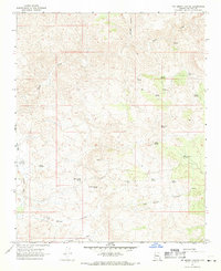
1967 Map of Tom Brown Canyon
USGS Topo · Published 1969About this map
Big Sandy River flows along the western edge of this Mohave County landscape, marking a transition between the river valley and the steep drainages of the Hualapai Mountains. The 1960s terrain is characterized by a dense network of water sources vital to this arid region, including named improvements like Lower Parson Well and the Buckley Tunnel Spring. These features, along with numerous others such as Indian Grade Spring and Warm Spring, suggest a history of ranching and livestock management in the canyons. The eastern boundary of the Hualapai Indian Res occupies the southwestern portion of the sheet, while the deep cut of Tom Brown Canyon dominates the southern topography. A lone Jeep Trail provides the primary transit route through the southern washes, connecting scattered points like the White Spring Well and Falls.
Find a feature on this map
23 named features on this map. Tap any name to fly to it.
Don’t see what you’re looking for? This feature index may not catch every label — zoom into the map to look around manually.
Map Details
Editions of this 1967 Tom Brown Canyon Map
2 editions found
Other maps of this area

1886 · Diamond Creek
USGS Topo · 1:250,000

1892 · Diamond Creek
USGS Topo · 1:250,000

1923 · Signal
USGS Topo · 1:250,000

1942 · Signal
USGS Topo · 1:250,000

1948 · Williams
USGS Topo · 1:250,000

1950 · Prescott
USGS Topo · 1:250,000

1954 · Prescott
USGS Topo · 1:250,000

1954 · Williams
USGS Topo · 1:250,000

1956 · Williams
USGS Topo · 1:250,000

1958 · Prescott
USGS Topo · 1:250,000