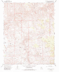
1967 Map of Tom Brown Canyon
USGS Topo · Published 1985About this map
Big Sandy River and its intricate drainage network define this high-desert reach of Mohave County during the late 1960s. The landscape is characterized by a high density of water sources essential for life in this arid environment, ranging from Blue Mary Spring and Indian Grade Spring to the strategically placed Upper Parson Well and Lower Parson Well. These points of water access, along with the Buckley Tunnel Spring, speak to the historical importance of controlling and tapping groundwater for livestock and human survival in the canyonlands.
Find a feature on this map
22 named features on this map. Tap any name to fly to it.
Don’t see what you’re looking for? This feature index may not catch every label — zoom into the map to look around manually.
Map Details
Editions of this 1967 Tom Brown Canyon Map
2 editions found
Other maps of this area

1886 · Diamond Creek
USGS Topo · 1:250,000

1892 · Diamond Creek
USGS Topo · 1:250,000

1923 · Signal
USGS Topo · 1:250,000

1942 · Signal
USGS Topo · 1:250,000

1948 · Williams
USGS Topo · 1:250,000

1950 · Prescott
USGS Topo · 1:250,000

1954 · Prescott
USGS Topo · 1:250,000

1954 · Williams
USGS Topo · 1:250,000

1956 · Williams
USGS Topo · 1:250,000

1958 · Prescott
USGS Topo · 1:250,000