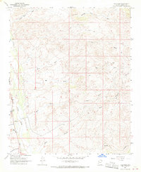
1967 Map of Tule Wash
USGS Topo · Published 1970About this map
Sandy River drainage patterns dominate this high-desert portion of Mohave County during the late 1960s, revealing a landscape defined by its network of ephemeral washes and steep canyons. The map centers on the confluence of the Big Wash and Tule Wash systems as they feed toward the river valley. Human presence is sparse but concentrated near the water, evidenced by the Valley Church and the small settlement of Stevens. An unimproved Landing Strip and various Jeep Trails suggest the region's reliance on air and off-road travel for accessibility.
Find a feature on this map
25 named features on this map. Tap any name to fly to it.
Don’t see what you’re looking for? This feature index may not catch every label — zoom into the map to look around manually.
Map Details
Editions of this 1967 Tule Wash Map
2 editions found
Other maps of this area

1923 · Signal
USGS Topo · 1:250,000

1942 · Signal
USGS Topo · 1:250,000

1950 · Prescott
USGS Topo · 1:250,000

1954 · Prescott
USGS Topo · 1:250,000

1958 · Prescott
USGS Topo · 1:250,000

1959 · Prescott
USGS Topo · 1:250,000

1960 · Prescott
USGS Topo · 1:250,000

1965 · Prescott
USGS Topo · 1:250,000
1967 · Gunsight Canyon
USGS Topo · 1:24,000
1967 · Pilgrim Wash
USGS Topo · 1:24,000