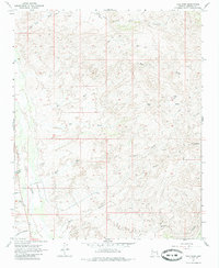
1967 Map of Tule Wash
USGS Topo · Published 1985About this map
Sandy River flows through the western edge of this Mohave County landscape, which is defined by an intricate network of drainage systems such as Big Tule Wash and Burro Wash. The 1960s terrain shows a quiet desert expanse with minimal human infrastructure, save for isolated markers of travel and community. Near the river, Valley Church and a nearby Landing Strip represent the small hubs of activity in this arid region, while a Corral and a Water Tank suggest the continued presence of ranching. Several named drainages, including Pearson Falls Wash and Bull Wash, feed into larger canyons like Red Canyon and Gunsight Canyon. A single Prospect in the northeast corner and scattered Jeep Trails offer clues for those tracing early mining efforts or historic routes through the high desert of Arizona.
Find a feature on this map
19 named features on this map. Tap any name to fly to it.
Don’t see what you’re looking for? This feature index may not catch every label — zoom into the map to look around manually.
Map Details
Editions of this 1967 Tule Wash Map
2 editions found
Other maps of this area

1923 · Signal
USGS Topo · 1:250,000

1942 · Signal
USGS Topo · 1:250,000

1950 · Prescott
USGS Topo · 1:250,000

1954 · Prescott
USGS Topo · 1:250,000

1958 · Prescott
USGS Topo · 1:250,000

1959 · Prescott
USGS Topo · 1:250,000

1960 · Prescott
USGS Topo · 1:250,000

1965 · Prescott
USGS Topo · 1:250,000
1967 · Gunsight Canyon
USGS Topo · 1:24,000
1967 · Pilgrim Wash
USGS Topo · 1:24,000