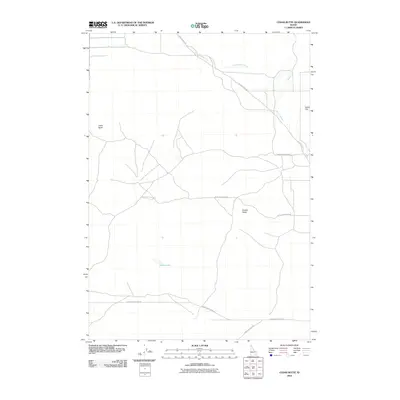
2010 Map of Cedar Butte
USGS Topo · Published 2010About this map
Cedar Butte and Camas Butte dominate this Jefferson County landscape, rising as prominent volcanic features above the surrounding flats. The map illustrates a high-desert environment where transportation routes like the Snake River Plain Rd and Camas Monteview Rd follow the natural contours of the land, connecting the isolated landmarks of the region. Water remains a scarce and defining element, represented by the ephemeral Cottonwood Creek and the meandering Beaver Creek, which flows past the expanse of Dutch Flat in the northeast. The presence of Rock Lakes suggests small basins that punctuate the arid terrain. This 2010 topographic record provides a clear look at the intersection of public lands and early 21st-century infrastructure, including Beaver Creek Rd and the access point at Camas Refuge Rd.
Find a feature on this map
10 named features on this map. Tap any name to fly to it.
Don’t see what you’re looking for? This feature index may not catch every label — zoom into the map to look around manually.
Map Details
Editions of this 2010 Cedar Butte Map
This is the sole edition of this map. No revisions or reprints were ever made.
Other maps of this area

1955 · Dubois
USGS Topo · 1:250,000

1955 · Idaho Falls
USGS Topo · 1:250,000

1958 · Dubois
USGS Topo · 1:250,000

1958 · Idaho Falls
USGS Topo · 1:250,000

1964 · Dubois NW
USGS Topo · 1:24,000

1964 · Lone Butte
USGS Topo · 1:24,000

1964 · Small
USGS Topo · 1:24,000

1964 · Cedar Butte SW
USGS Topo · 1:24,000
1964 · Hamer
USGS Topo · 1:24,000

1964 · Mud Lake NW
USGS Topo · 1:24,000