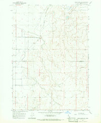
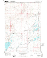
1964 Map of Cedar Butte SW
USGS Topo · Published 1965About this map
Medicine Lodge Creek winds through this high-desert landscape in the mid-1960s, marking a vital water source in an otherwise arid expanse. The map highlights the reliance on groundwater in this part of Idaho, with numerous scattered Well and Wells labels indicating localized agricultural or ranching activity across the terrain.
Find a feature on this map
4 named features on this map. Tap any name to fly to it.
Don’t see what you’re looking for? This feature index may not catch every label — zoom into the map to look around manually.
Map Details
Editions of this 1964 Cedar Butte SW Map
This is the sole edition of this map. No revisions or reprints were ever made.
Other maps of this area

1955 · Dubois
USGS Topo · 1:250,000

1955 · Idaho Falls
USGS Topo · 1:250,000

1958 · Dubois
USGS Topo · 1:250,000

1958 · Idaho Falls
USGS Topo · 1:250,000
1964 · Lone Butte
USGS Topo · 1:24,000
1964 · Small
USGS Topo · 1:24,000
1964 · Mud Lake NW
USGS Topo · 1:24,000
1964 · Rays Lake
USGS Topo · 1:24,000
1964 · Cedar Butte SE
USGS Topo · 1:24,000
1969 · Lidy Hot Springs SE
USGS Topo · 1:24,000