
1964 Map of Lone Butte
USGS Topo · Published 1965About this map
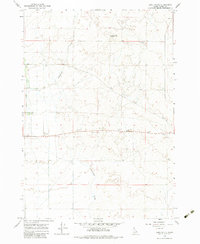
Lone Butte dominates the high desert landscape of Clark County in this mid-1960s topographical study. The terrain is defined by the drainage of Medicine Lodge Creek and Cottonwood Creek, which cut through a region primarily utilized for dryland agriculture and resource extraction. Evidence of local infrastructure is found in isolated landmarks like the Water Tank and Storage Bin, while the label Wheat suggests the primary crop of the area's agricultural plots. Industrial activity is indicated by a string of Borrow Pits and Gravel Pits concentrated near the center of the sheet, reflecting the road-building and maintenance needs of the period. Near the southeastern corner, the benchmark Dubois 5708 provides a specific reference point for the elevation of this high plateau country.
Find a feature on this map
14 named features on this map. Tap any name to fly to it.
Don’t see what you’re looking for? This feature index may not catch every label — zoom into the map to look around manually.
Map Details
Editions of this 1964 Lone Butte Map
2 editions found
Other maps of this area

1955 · Dubois
USGS Topo · 1:250,000

1957 · Paul Reservoir
USGS Topo · 1:62,500

1958 · Dubois
USGS Topo · 1:250,000

1964 · Dubois NW
USGS Topo · 1:24,000

1964 · Small
USGS Topo · 1:24,000

1964 · Cedar Butte SW
USGS Topo · 1:24,000

1964 · Camas
USGS Topo · 1:24,000

1964 · Cedar Butte SE
USGS Topo · 1:24,000

1972 · Spencer South
USGS Topo · 1:24,000

1983 · Dubois
USGS Topo · 1:100,000