1964 Map of Camas
USGS Topo · Published 1966About this map
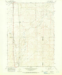
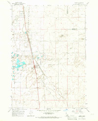
Dutch Flat dominates the northwestern portion of this mid-1960s survey, illustrating a high-desert landscape defined by sparse water sources and essential transportation corridors. The Union Pacific railroad runs a straight line south through the center of the sheet, passing through Jones Crossing and paralleling Beaver Creek. This north-south axis provided a vital link for local industry and ranching, evidenced by several scattered Gravel Pits and various wells located along the drainage basins.
Find a feature on this map
15 named features on this map. Tap any name to fly to it.
Don’t see what you’re looking for? This feature index may not catch every label — zoom into the map to look around manually.
Map Details
Editions of this 1964 Camas Map
2 editions found
Other maps of this area

1955 · Dubois
USGS Topo · 1:250,000

1955 · Idaho Falls
USGS Topo · 1:250,000

1958 · Dubois
USGS Topo · 1:250,000

1958 · Idaho Falls
USGS Topo · 1:250,000
1964 · Dubois NW
USGS Topo · 1:24,000
1964 · Lone Butte
USGS Topo · 1:24,000
1964 · Dubois NE
USGS Topo · 1:24,000
1964 · Hamer
USGS Topo · 1:24,000
1964 · Rays Lake
USGS Topo · 1:24,000
1964 · Dubois SE
USGS Topo · 1:24,000