
1964 Map of Small
USGS Topo · Published 1965About this map
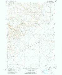
Medicine Lodge Creek dominates the eastern drainage of this high-desert landscape in Clark County, where the small settlement of Small sits at the base of the foothills. Mapped during the early 1960s, the terrain reveals a transition from the narrow canyon of Deep Creek to the open flats marked by numerous bench marks like BM 5281. The map captures a moment of specific land use, showing a Prospect and several Gravel Pits indicating early resource extraction in the region.
Find a feature on this map
17 named features on this map. Tap any name to fly to it.
Don’t see what you’re looking for? This feature index may not catch every label — zoom into the map to look around manually.
Map Details
Editions of this 1964 Small Map
2 editions found
Other maps of this area

1955 · Dubois
USGS Topo · 1:250,000

1957 · Paul Reservoir
USGS Topo · 1:62,500

1957 · Edie Ranch
USGS Topo · 1:62,500

1958 · Dubois
USGS Topo · 1:250,000

1964 · Lone Butte
USGS Topo · 1:24,000

1964 · Cedar Butte SW
USGS Topo · 1:24,000

1964 · Cedar Butte SE
USGS Topo · 1:24,000

1969 · Lidy Hot Springs SE
USGS Topo · 1:24,000

1969 · Lidy Hot Springs
USGS Topo · 1:24,000

1983 · Dubois
USGS Topo · 1:100,000