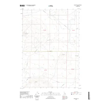
2020 Map of Cedar Butte
USGS Topo · Published 2020About this map
Cedar Butte and Camas Butte dominate the landscape of the Snake River Plain at the Jefferson and Clark County line. This area is defined by its volcanic topography and a network of arterial roads that navigate the high desert floor, including the long stretches of Snake River Plain Rd and Beaver Creek Rd. The sparse drainage patterns are visible through Beaver Cr and Cottonwood Cr in the northern reaches, while the seasonal Rock Lakes sit south of the county boundary. Evidence of early grazing and transit can be traced to Dutch Flat in the northeast. The presence of Camas Refuge Rd near Table Butte reflects the proximity to significant wildlife management areas, where the desert gives way to more complex hydrological features in an otherwise arid expanse.
Find a feature on this map
17 named features on this map. Tap any name to fly to it.
Don’t see what you’re looking for? This feature index may not catch every label — zoom into the map to look around manually.
Map Details
Editions of this 2020 Cedar Butte Map
This is the sole edition of this map. No revisions or reprints were ever made.
Other maps of this area

1955 · Dubois
USGS Topo · 1:250,000

1955 · Idaho Falls
USGS Topo · 1:250,000

1958 · Dubois
USGS Topo · 1:250,000

1958 · Idaho Falls
USGS Topo · 1:250,000

1964 · Dubois NW
USGS Topo · 1:24,000

1964 · Lone Butte
USGS Topo · 1:24,000

1964 · Small
USGS Topo · 1:24,000

1964 · Cedar Butte SW
USGS Topo · 1:24,000
1964 · Hamer
USGS Topo · 1:24,000

1964 · Mud Lake NW
USGS Topo · 1:24,000