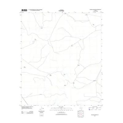
2012 Map of Cedar Canyon
USGS Topo · Published 2012About this map
Cedar Canyon and the high point of Cedar Hill define this corner of Crockett County, where a vast network of water infrastructure supports the arid West Texas ranching landscape. The distribution of features reveals a reliance on underground water sources, marked by numerous named wind-powered pumps such as Munro Windmill, Red Tower Windmill, and the Twenty-Five Foot Windmill. These landmarks, alongside human-made catchments like Jacks Tank and Rock Tank, trace the legacy of pastoral land use in a region where water security dictates human activity. Sparse roads like Mobile Rd navigate the terrain around Round Mtn, connecting these vital water stations across the canyon floor and high plateaus. The presence of the Oil Well Windmill suggests a convergence of traditional water pumping with the region's energy development history.
Find a feature on this map
18 named features on this map. Tap any name to fly to it.
Don’t see what you’re looking for? This feature index may not catch every label — zoom into the map to look around manually.
Map Details
Editions of this 2012 Cedar Canyon Map
This is the sole edition of this map. No revisions or reprints were ever made.
Other maps of this area
1928 · Crane
USGS Topo · 1:125,000
1928 · Rankin
USGS Topo · 1:125,000

1929 · Sheffield
USGS Topo · 1:125,000
1929 · Independence Draw Quadrangle
USGS Topo · 1:125,000

1954 · Pecos
USGS Topo · 1:250,000

1954 · Fort Stockton
USGS Topo · 1:250,000

1954 · Sonora
USGS Topo · 1:250,000

1954 · San Angelo
USGS Topo · 1:250,000

1957 · Pecos
USGS Topo · 1:250,000

1958 · Sonora
USGS Topo · 1:250,000