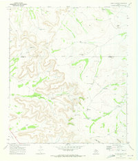
1970 Map of Cedar Canyon
USGS Topo · Published 1973About this map
Cedar Canyon carves a path through the limestone uplands along the border of Upton and Crockett counties, reflecting a landscape defined by water management and mineral exploration. In this arid West Texas terrain, the 1970 field survey reveals a network of essential water features including Noelke Creek, Jacks Tank, and numerous family-named landmarks like Munro Windmill and Carter Windmill. These structures, along with the Telephone Windmill, demonstrate the infrastructure required for ranching in such an isolated environment.
Find a feature on this map
26 named features on this map. Tap any name to fly to it.
Don’t see what you’re looking for? This feature index may not catch every label — zoom into the map to look around manually.
Map Details
Editions of this 1970 Cedar Canyon Map
This is the sole edition of this map. No revisions or reprints were ever made.
Other maps of this area

1928 · Crane
USGS Topo · 1:125,000

1928 · Rankin
USGS Topo · 1:125,000

1929 · Sheffield
USGS Topo · 1:125,000

1929 · Independence Draw Quadrangle
USGS Topo · 1:125,000

1954 · Pecos
USGS Topo · 1:250,000

1954 · Fort Stockton
USGS Topo · 1:250,000

1954 · Sonora
USGS Topo · 1:250,000

1954 · San Angelo
USGS Topo · 1:250,000

1957 · Pecos
USGS Topo · 1:250,000

1958 · Sonora
USGS Topo · 1:250,000