
1958 Map of Cedar City
USGS Topo · Published 1958About this map
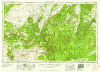
St George and Cedar City anchor this mid-century survey of the southwestern Utah frontier, where the high desert meets the southern plateaus. The map documents a landscape defined by dramatic geological transitions, from the Escalante Desert in the northwest to the towering Pink Cliffs and Markagunt Plateau in the east. Local industry is clearly visible through the presence of the Desert Western Mine and the Silver Reef Mine, the latter noting its extraction of both silver and uranium during the height of the atomic era.
Find a feature on this map
127 named features on this map. Tap any name to fly to it.
Don’t see what you’re looking for? This feature index may not catch every label — zoom into the map to look around manually.
Map Details
Editions of this 1958 Cedar City Map
2 editions found
Other maps of this area

1885 · St. George
USGS Topo · 1:250,000

1885 · Beaver
USGS Topo · 1:250,000

1885 · Fish Lake
USGS Topo · 1:250,000

1885 · Pioche
USGS Topo · 1:250,000

1886 · Kanab
USGS Topo · 1:250,000

1886 · Escalante
USGS Topo · 1:250,000

1886 · Saint Thomas
USGS Topo · 1:250,000

1886 · Mt. Trumbull
USGS Topo · 1:250,000

1886 · Echo Cliffs
USGS Topo · 1:250,000

1886 · Pioche
USGS Topo · 1:250,000