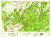
1958 Map of Cedar City
USGS Topo · Published 1958About this map
Cedar City and St George serve as the primary anchors of this southwestern Utah landscape, which is defined by dramatic vertical transitions across the Hurricane Cliffs and the rising Markagunt Plateau. The region’s 1950s economic life is evident in the industrial footprints of Iron Mountain and Iron Springs, where rail spurs of the Union Pacific connect mining operations to the broader Western network. This survey captures a moment when early recreation and preservation were firmly established at Zion National Park and Bryce Canyon National Park, while smaller settlements like Beryl and Newcastle maintained agricultural footholds in the arid Escalante Desert.
Find a feature on this map
120 named features on this map. Tap any name to fly to it.
Don’t see what you’re looking for? This feature index may not catch every label — zoom into the map to look around manually.
Map Details
Editions of this 1958 Cedar City Map
2 editions found

Other maps of this area

1885 · St. George
USGS Topo · 1:250,000

1885 · Beaver
USGS Topo · 1:250,000

1885 · Fish Lake
USGS Topo · 1:250,000

1885 · Pioche
USGS Topo · 1:250,000

1886 · Kanab
USGS Topo · 1:250,000

1886 · Escalante
USGS Topo · 1:250,000

1886 · Saint Thomas
USGS Topo · 1:250,000

1886 · Mt. Trumbull
USGS Topo · 1:250,000

1886 · Echo Cliffs
USGS Topo · 1:250,000

1886 · Pioche
USGS Topo · 1:250,000