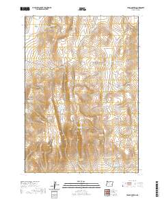
2020 Map of Cedar Mountain
USGS Topo · Published 2020About this map
Cedar Mountain stands as a prominent elevation in this high desert section of Malheur County, overlooking a landscape defined by an extensive system of water management. The terrain is characterized by numerous small-scale water collection points, such as Cook Stove Reservoir and the uniquely named Hard Time Reservoir. These features, along with the Cook Stove Basin, suggest a historical reliance on seasonal water catchments for ranching and land use in an arid environment. Transportation through the area is anchored by Crowley Rd and Antelope Flat Rd, providing access to isolated landmarks like Little Mud Flat and the headwaters of Butte Cr. The network of basins and reservoirs, including Long Walk Reservoir and Burnt Stump Reservoir, provides a detailed look at how geography was adapted for survival and industry in this corner of the state.
Find a feature on this map
28 named features on this map. Tap any name to fly to it.
Don’t see what you’re looking for? This feature index may not catch every label — zoom into the map to look around manually.
Map Details
Editions of this 2020 Cedar Mountain Map
This is the sole edition of this map. No revisions or reprints were ever made.
Other maps of this area
1955 · Boise
USGS Topo · 1:250,000
1958 · Boise
USGS Topo · 1:250,000
1962 · Boise
USGS Topo · 1:250,000
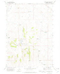
1972 · Cedar Mountain
USGS Topo · 1:24,000
1972 · Burnt Flat
USGS Topo · 1:24,000
1972 · Big Mud Flat
USGS Topo · 1:24,000
1972 · Wall Rock Springs
USGS Topo · 1:24,000
1972 · Sacramento Butte
USGS Topo · 1:24,000
1972 · Rinehart Canyon
USGS Topo · 1:24,000
1972 · Copeland Reservoirs
USGS Topo · 1:24,000