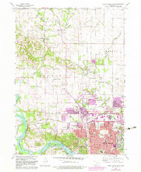
1967 Map of Cedar Rapids North
USGS Topo · Published 1983About this map
Cedar Rapids and its northern suburbs are captured in this mid-century period of rapid expansion, where the rural landscapes of Monroe and Marion townships began transitioning into urban residential zones. The purple-tinted overprints highlight significant growth around Hiawatha and Robins, following the paths of the Illinois Central and Milwaukee Road railroads. Along the Cedar River, industrial and recreational spaces like Ellis Park and Seminole Valley Park parallel the water's edge, while the city's interior is densely packed with community landmarks like Regis High Sch and Kenwood Sch.
Find a feature on this map
104 named features on this map. Tap any name to fly to it.
Don’t see what you’re looking for? This feature index may not catch every label — zoom into the map to look around manually.
Map Details
Editions of this 1967 Cedar Rapids North Map
2 editions found
Other maps of this area

1887 · Cedar Rapids
USGS Topo · 1:62,500

1888 · Shellsburg
USGS Topo · 1:62,500

1888 · Marion
USGS Topo · 1:62,500

1888 · Amana
USGS Topo · 1:62,500

1889 · Marion
USGS Topo · 1:62,500

1889 · Amana
USGS Topo · 1:62,500

1889 · Shellsburg
USGS Topo · 1:62,500

1891 · Cedar Rapids
USGS Topo · 1:62,500

1899 · Amana
USGS Topo · 1:62,500

1899 · Shellsburg
USGS Topo · 1:62,500