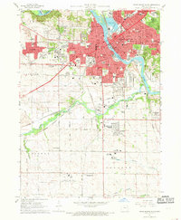
1967 Map of Cedar Rapids South
USGS Topo · Published 1969About this map
Cedar Rapids serves as the industrial and transportation hub for Linn County, centered on the Cedar River and its Municipal Island. During the late 1960s, the city's southward expansion is evident in the residential developments of Cedar Hills and the specialized enclave of Lincolnway Village. The landscape is a dense network of rail infrastructure, including the Illinois Central, Chicago and North Western, and the Cedar Rapids and Iowa City lines, which supported the local manufacturing and agricultural economy.
Find a feature on this map
75 named features on this map. Tap any name to fly to it.
Don’t see what you’re looking for? This feature index may not catch every label — zoom into the map to look around manually.
Map Details
Editions of this 1967 Cedar Rapids South Map
3 editions found
Other maps of this area

1887 · Cedar Rapids
USGS Topo · 1:62,500

1888 · Shellsburg
USGS Topo · 1:62,500

1888 · Marion
USGS Topo · 1:62,500

1888 · Amana
USGS Topo · 1:62,500

1889 · Marion
USGS Topo · 1:62,500

1889 · Amana
USGS Topo · 1:62,500

1889 · Shellsburg
USGS Topo · 1:62,500

1891 · Cedar Rapids
USGS Topo · 1:62,500

1899 · Amana
USGS Topo · 1:62,500

1899 · Shellsburg
USGS Topo · 1:62,500
Featured Places
- Cedar Rapids, IA
- Summit, Cedar Rapids
- West Cedar Rapids, Cedar Rapids
- Worthington Acres, Cedar Rapids
- Linn County, IA