
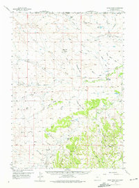
1957 Map of Cedar Ridge
USGS Topo · Published 1959About this map
Cedar Ridge rises as a prominent landmark along the boundary where Carter Co, Montana, meets Crook Co, Wyoming. This mid-century survey documents a high-plains landscape defined by seasonal drainages like Battle Creek and the meandering course of the Little Missouri River. The settlement pattern reflects the ranching and resource-extraction economy of the 1950s, scattered with rural outposts such as Leonard Ranch and Storm Ranch. Remote education centers are surprisingly frequent, with Thompson Creek Sch, Storm Sch, Hulett Creek Sch, and Wood Sch serving the local families. Industrial activity is represented by the Blackbanks site, several Oil Well locations, and the Fortunate Mines in the southern reaches. The map also traces a long Pipeline cutting through the terrain, illustrating the infrastructure required to transport energy resources from these sparsely populated borderlands.
Find a feature on this map
54 named features on this map. Tap any name to fly to it.
Don’t see what you’re looking for? This feature index may not catch every label — zoom into the map to look around manually.
Map Details
Editions of this 1957 Cedar Ridge Map
2 editions found
Other maps of this area

1905 · Devils Tower
USGS Topo · 1:125,000

1954 · Strawberry Hill
USGS Topo · 1:24,000

1954 · Storm Hill
USGS Topo · 1:24,000

1954 · Ekalaka
USGS Topo · 1:250,000

1954 · Gillette
USGS Topo · 1:250,000

1955 · Devils Tower
USGS Topo · 1:62,500

1955 · Gillette
USGS Topo · 1:250,000

1956 · Ekalaka
USGS Topo · 1:250,000

1957 · Oshoto
USGS Topo · 1:62,500

1957 · Seely
USGS Topo · 1:62,500