
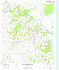
1962 Map of Cedar Springs
USGS Topo · Published 1964About this map
Fort Milam (Site) overlooks the winding course of the Brazos River, marking a point of historical significance near The Falls. This 1960s landscape in Falls County reflects a rural economy shaped by proximity to the river and the Missouri Pacific railroad. The settlement of Cedar Springs serves as a local hub, anchored by the Cedar Springs Ch, while smaller communities like Pleasant Grove and Perry dot the surrounding acreage.
Find a feature on this map
35 named features on this map. Tap any name to fly to it.
Don’t see what you’re looking for? This feature index may not catch every label — zoom into the map to look around manually.
Map Details
Editions of this 1962 Cedar Springs Map
2 editions found
Other maps of this area

1892 · Temple
USGS Topo · 1:125,000

1954 · Waco
USGS Topo · 1:250,000

1955 · Waco
USGS Topo · 1:250,000

1957 · McClanahan
USGS Topo · 1:24,000

1957 · Chilton
USGS Topo · 1:24,000

1957 · Marlin
USGS Topo · 1:24,000

1961 · Baileyville
USGS Topo · 1:24,000

1962 · Rosebud
USGS Topo · 1:24,000

1962 · Reagan
USGS Topo · 1:24,000
1963 · Westphalia
USGS Topo · 1:24,000