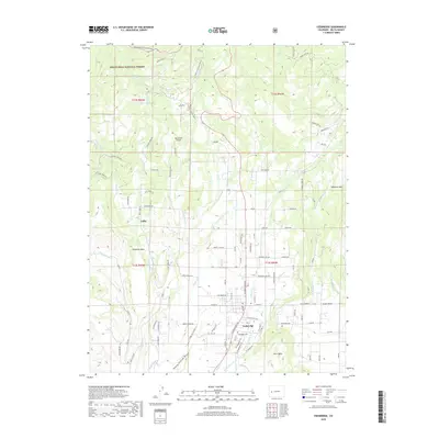
2019 Map of Cedaredge
USGS Topo · Published 2019About this map
The town of Cedaredge serves as the gateway to the southern slopes of the massive flat-topped Grand Mesa during the late 2010s. This agricultural and forest landscape is defined by an intricate network of irrigation systems necessary for high-altitude orchard and ranching operations, including the Orchard City Aqueduct, Highline Ditch, and Cedar Run Ditch. The geography transitions from the residential streets of Cedaredge and the smaller settlement of Colby into the protected lands of the Grand Mesa National Forest. Transportation routes like the Grand Mesa Scenic Byway and State Hwy 65 provide access to higher elevations, passing landmarks such as Mesawood Airpark and Bluenose Mesa. Researchers can trace the path of numerous watercourses like Surface Cr and Ward Cr as they flow toward Harts Basin, illustrating the vital connection between natural hydrology and local development.
Find a feature on this map
97 named features on this map. Tap any name to fly to it.
Don’t see what you’re looking for? This feature index may not catch every label — zoom into the map to look around manually.
Map Details
Editions of this 2019 Cedaredge Map
This is the sole edition of this map. No revisions or reprints were ever made.
Other maps of this area

1955 · Grand Mesa
USGS Topo · 1:24,000

1955 · Lazear
USGS Topo · 1:24,000

1955 · Skyway
USGS Topo · 1:24,000

1956 · Montrose
USGS Topo · 1:250,000

1956 · Moab
USGS Topo · 1:250,000

1956 · Grand Junction
USGS Topo · 1:250,000

1957 · Leadville
USGS Topo · 1:250,000

1959 · Grand Junction
USGS Topo · 1:250,000

1959 · Moab
USGS Topo · 1:250,000

1959 · Leadville
USGS Topo · 1:250,000