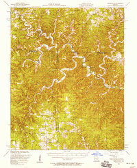
1951 Map of Cedargrove
USGS Topo · Published 1958About this map
Montauk State Park and the headwaters of the Current River dominate this Ozark landscape, reflecting a mid-century balance between conservation and rural Missouri life. The map reveals an intricate network of hollows—such as Pigeon Creek, Ashley Creek, and Gladden Creek—that dictated the placement of small community centers like Cedargrove, Jadwin, and Hartshorn. The high density of educational and spiritual landmarks, including South Cross Roads School and Center Valley Church, underscores the dispersed yet connected nature of these settlements before the era of school consolidation.
Find a feature on this map
85 named features on this map. Tap any name to fly to it.
Don’t see what you’re looking for? This feature index may not catch every label — zoom into the map to look around manually.
Map Details
Editions of this 1951 Cedargrove Map
3 editions found
Other maps of this area

1915 · Eminence
USGS Topo · 1:62,500

1917 · Eminence
USGS Topo · 1:62,500

1932 · Cedar Grove
USGS Topo · 1:48,000

1937 · Edgar Springs
USGS Topo · 1:48,000

1941 · Salem
USGS Topo · 1:62,500

1941 · Stone Hill
USGS Topo · 1:62,500

1945 · Salem
USGS Topo · 1:62,500

1945 · Edgar Springs
USGS Topo · 1:62,500

1945 · Stone Hill
USGS Topo · 1:62,500

1945 · Round Spring
USGS Topo · 1:62,500