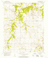
1956 Map of Cedarville
USGS Topo · Published 1957About this map
Cedar Creek and its many winding tributaries, including Goose Creek and Greaser Creek, define the topography of this rural Missouri landscape in the mid-1950s. The map captures a transition between the townships of Benton, Linn, Cedar, North, and Ernest, with the boundary between Cedar and Dade counties bisecting the central terrain. Small rural hubs like Cedarville and Arcola serve as focal points for the surrounding farmsteads, while the settlement of Omer is situated along the upper reaches of Omer Branch.
Find a feature on this map
29 named features on this map. Tap any name to fly to it.
Don’t see what you’re looking for? This feature index may not catch every label — zoom into the map to look around manually.
Map Details
Editions of this 1956 Cedarville Map
This is the sole edition of this map. No revisions or reprints were ever made.
Other maps of this area

1886 · Nevada
USGS Topo · 1:125,000

1886 · Stockton
USGS Topo · 1:125,000

1886 · Greenfield
USGS Topo · 1:125,000

1886 · Carthage
USGS Topo · 1:125,000

1888 · Greenfield
USGS Topo · 1:125,000

1894 · Nevada
USGS Topo · 1:125,000

1894 · Carthage
USGS Topo · 1:125,000

1947 · Joplin
USGS Topo · 1:250,000

1949 · Joplin
USGS Topo · 1:250,000

1954 · Springfield
USGS Topo · 1:250,000