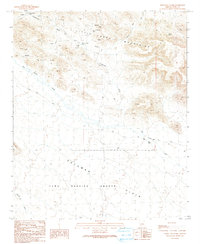
1990 Map of Cementosa Wash
USGS Topo · Published 1990About this map
The Little Horn Mountains define the northern terrain of this quadrangle, revealing a history of desert prospecting and early mining efforts. Mapping from 1990 shows several industrial markers, including the Allison Mine, Oakland Mine, and various Adits and a Mine Shaft tucked into the mountain slopes. These sites suggest a period of active exploration for minerals before the landscape was primarily designated for other uses. To the south, the topography transitions into the broad Palomas Plain, much of which falls within the boundaries of the Yuma Proving Ground. Water sources in this arid environment are critical, noted by labels such as Soldiers Tank (Cistern) and Sievers Tank, which likely served both miners and travelers along Hovatter Road and Red Raven Road. The complex drainage system of Cementosa Wash and Red Raven Wash illustrates the seasonal flow patterns of the Arizona desert.
Find a feature on this map
18 named features on this map. Tap any name to fly to it.
Don’t see what you’re looking for? This feature index may not catch every label — zoom into the map to look around manually.
Map Details
Editions of this 1990 Cementosa Wash Map
This is the sole edition of this map. No revisions or reprints were ever made.
Other maps of this area

1942 · Vicksburg
USGS Topo · 1:250,000

1954 · Phoenix
USGS Topo · 1:250,000

1957 · Phoenix
USGS Topo · 1:250,000

1958 · Phoenix
USGS Topo · 1:250,000

1960 · Phoenix
USGS Topo · 1:250,000

1962 · Little Horn Mts
USGS Topo · 1:62,500

1962 · Kofa Butte
USGS Topo · 1:62,500
1965 · Engesser Pass
USGS Topo · 1:62,500
1965 · Palomas Mts
USGS Topo · 1:62,500

1969 · Phoenix
USGS Topo · 1:250,000