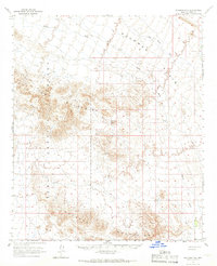
1965 Map of Palomas Mts
USGS Topo · Published 1966About this map
The Palomas Mountains and Tank Proving Ground Mountains dominate this mid-century desert landscape, where water management was essential for any survival or industry. Isolated water sources like Snyders Well, Jims Well, and several unnamed Waterholes are scattered across the arid terrain, illustrating the critical infrastructure needed for cattle or prospecting in the Yuma County desert. The presence of the Golden Harp Mine suggests the region's mineral interests, while the topographical detail of Flat Top Butte and the drainage patterns of Hoodoo Wash and Red Raven Wash reveal the erosional character of the Sonoran landscape during the 1960s.
Find a feature on this map
19 named features on this map. Tap any name to fly to it.
Don’t see what you’re looking for? This feature index may not catch every label — zoom into the map to look around manually.
Map Details
Editions of this 1965 Palomas Mts Map
2 editions found
Other maps of this area

1927 · Hyder
USGS Topo · 1:62,500

1928 · Norton
USGS Topo · 1:62,500

1929 · Aztec
USGS Topo · 1:62,500

1929 · Norton
USGS Topo · 1:62,500

1930 · Stoval
USGS Topo · 1:62,500

1930 · Hyder
USGS Topo · 1:62,500

1942 · Vicksburg
USGS Topo · 1:250,000

1950 · Stoval
USGS Topo · 1:62,500

1950 · Aztec
USGS Topo · 1:62,500

1953 · Ajo
USGS Topo · 1:250,000