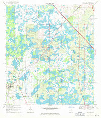
1969 Map of Center Hill
USGS Topo · Published 1971About this map
Center Hill and Okahumpka anchor this 1969 topographic portrait of the wet, sinkhole-dotted landscape straddling the Sumter Co Lake Co line. The terrain is defined by a complex mosaic of marshes, ponds, and prairie, notably Wilson Marsh and the sprawling Hampton Prairie. Transportation and industry dominate the corridor, with the Floridas Turnpike Toll Road and the Seaboard Coast Line railroad cutting diagonal paths across the wetlands. This era shows the local economy's reliance on both agriculture and mineral extraction, evidenced by the University of Florida State Experimental Farm and numerous claypits. Genealogists will find value in the presence of Cool Spring Cem and Merritt Cem, alongside water bodies like Palatlakaha River and the Jumper Creek Canal.
Find a feature on this map
34 named features on this map. Tap any name to fly to it.
Don’t see what you’re looking for? This feature index may not catch every label — zoom into the map to look around manually.
Map Details
Editions of this 1969 Center Hill Map
This is the sole edition of this map. No revisions or reprints were ever made.
Other maps of this area

1893 · Panasoffkee
USGS Topo · 1:62,500

1895 · Panasoffkee
USGS Topo · 1:62,500

1955 · Plant City
USGS Topo · 1:250,000

1955 · Orlando
USGS Topo · 1:250,000

1957 · Orlando
USGS Topo · 1:250,000

1958 · Orlando
USGS Topo · 1:250,000

1958 · Plant City
USGS Topo · 1:250,000

1958 · Webster
USGS Topo · 1:24,000

1958 · Bushnell
USGS Topo · 1:24,000

1959 · Plant City
USGS Topo · 1:250,000