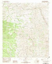
1982 Map of Center Peak
USGS Topo · Published 1982About this map
The Animas Mountains dominate this high-altitude landscape in the bootheel region of New Mexico, where the Continental Divide winds through some of the state's most isolated terrain. The map centers on Center Peak, a prominent landmark within a geography defined by steep canyons and named summits like Elephant Butte and K Peak. Water management for ranching is the primary indicator of human activity in this arid environment, evidenced by a network of specialized reservoirs such as Rock Guard Tank, Tahoe Tank, and Lower Walnut Tank. These features, alongside drainages like Gillespie Creek and Cowboy Creek, reveal a landscape shaped by the necessity of water storage. Below Cowboy Rim, the land transitions into a series of washes and forks, including the Middle Fork and East Fork of Brushy Creek, illustrating the complex drainage patterns of the southwestern divide.
Find a feature on this map
26 named features on this map. Tap any name to fly to it.
Don’t see what you’re looking for? This feature index may not catch every label — zoom into the map to look around manually.
Map Details
Editions of this 1982 Center Peak Map
This is the sole edition of this map. No revisions or reprints were ever made.
Other maps of this area

1917 · Antelope Wells
USGS Topo · 1:62,500

1918 · Walnut Wells
USGS Topo · 1:62,500

1918 · Cienega Springs
USGS Topo · 1:62,500

1918 · Animas Peak
USGS Topo · 1:62,500

1919 · Antelope Wells
USGS Topo · 1:62,500

1920 · Animas Peak
USGS Topo · 1:62,500

1923 · Walnut Wells
USGS Topo · 1:62,500

1955 · Douglas
USGS Topo · 1:250,000

1959 · Douglas
USGS Topo · 1:250,000

1961 · Douglas
USGS Topo · 1:250,000