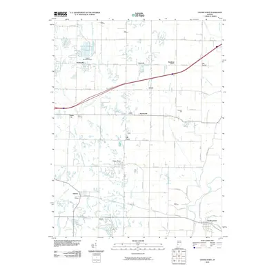
2010 Map of Center Point
USGS Topo · Published 2010About this map
Center Point sits at the heart of this Clay County landscape, where the agricultural grid is broken by the winding courses of Birch Creek and Hog Creek. The area maintains a dense network of local history markers, including family-named sites such as Walker Cemetery, Miller Cemetery, and Gremes Cemetery. In the northern section, Hoosierville and the Arthur Municipal Airport reflect the mix of rural settlement and light infrastructure, while Vinegar Hill provides a rare point of named relief in the terrain.
Find a feature on this map
48 named features on this map. Tap any name to fly to it.
Don’t see what you’re looking for? This feature index may not catch every label — zoom into the map to look around manually.
Map Details
Editions of this 2010 Center Point Map
This is the sole edition of this map. No revisions or reprints were ever made.
Other maps of this area

1908 · Clay City
USGS Topo · 1:48,000

1910 · Clay City
USGS Topo · 1:62,500

1950 · Brazil East
USGS Topo · 1:24,000

1950 · Brazil West
USGS Topo · 1:24,000

1952 · Reelsville
USGS Topo · 1:24,000

1953 · Indianapolis
USGS Topo · 1:250,000

1956 · Indianapolis
USGS Topo · 1:250,000

1956 · Patricksburg
USGS Topo · 1:24,000

1957 · Indianapolis
USGS Topo · 1:250,000
1957 · Center Point
USGS Topo · 1:24,000