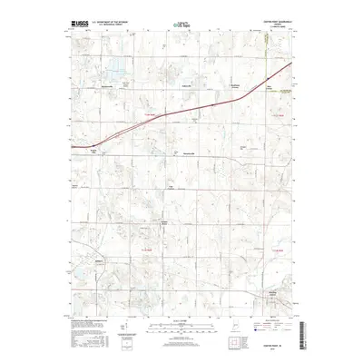
2016 Map of Center Point
USGS Topo · Published 2016About this map
The Eel River valley and its surrounding tributaries form the geographic heart of this Clay County landscape, where small crossroads communities and family cemeteries anchor the rural grid. In the southern reach, Bowling Green sits near the confluence of Jordan Creek and the river, while the town of Center Point serves as a central hub for the township. The landscape is marked by a network of drainage ways like McIntyre Cr and Hog Cr, interspersed with agricultural prairie land such as Wheeler Prairie. Higher ground is found at Vinegar Hill and near the Brazil Clay County Airport. For those tracing local heritage, the map identifies numerous burial sites including Walker Cem, Zenor Cem, and Moss Cem, alongside vanished or diminished hamlets like Prairie City and Ashboro. A variety of water bodies, including the Lake in the Woods and Dietz Lake, provide distinct landmarks within the undulating terrain.
Find a feature on this map
67 named features on this map. Tap any name to fly to it.
Don’t see what you’re looking for? This feature index may not catch every label — zoom into the map to look around manually.
Map Details
Editions of this 2016 Center Point Map
This is the sole edition of this map. No revisions or reprints were ever made.
Other maps of this area

1908 · Clay City
USGS Topo · 1:48,000

1910 · Clay City
USGS Topo · 1:62,500

1950 · Brazil East
USGS Topo · 1:24,000

1950 · Brazil West
USGS Topo · 1:24,000

1952 · Reelsville
USGS Topo · 1:24,000

1953 · Indianapolis
USGS Topo · 1:250,000

1956 · Indianapolis
USGS Topo · 1:250,000

1956 · Patricksburg
USGS Topo · 1:24,000

1957 · Indianapolis
USGS Topo · 1:250,000
1957 · Center Point
USGS Topo · 1:24,000