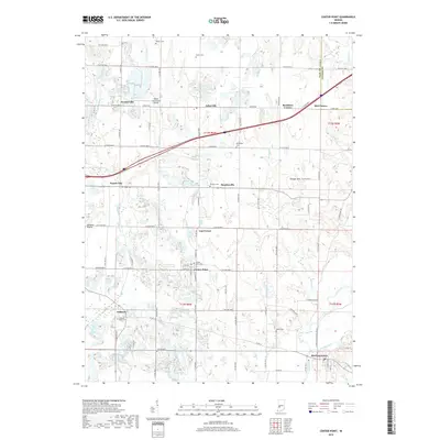
2019 Map of Center Point
USGS Topo · Published 2019About this map
Center Point sits at the heart of this Indiana landscape, where local life is defined by a dense network of country roads and scattered family cemeteries. The terrain transitions from the open expanses of Wheeler Prairie in the west to the winding course of the Eel River in the southeast. Numerous small crossroads settlements, including Lap Corner, Stearleyville, and Ashboro, punctuate the rural grid, suggesting a long history of agricultural community hubs. Genealogy researchers will find significant value in the distribution of burial sites like Walker Cem, Killion Cem, and the Ashboro - Moss Cem, which are tucked away near creek drainages and section lines. The northern portion of the map is dominated by the Brazil Clay County Airport and the modern path of the interstate, contrasting with the more traditional land patterns found near Bowling Green and along the banks of Jordan Creek.
Find a feature on this map
62 named features on this map. Tap any name to fly to it.
Don’t see what you’re looking for? This feature index may not catch every label — zoom into the map to look around manually.
Map Details
Editions of this 2019 Center Point Map
This is the sole edition of this map. No revisions or reprints were ever made.
Other maps of this area

1908 · Clay City
USGS Topo · 1:48,000

1910 · Clay City
USGS Topo · 1:62,500

1950 · Brazil East
USGS Topo · 1:24,000

1950 · Brazil West
USGS Topo · 1:24,000

1952 · Reelsville
USGS Topo · 1:24,000

1953 · Indianapolis
USGS Topo · 1:250,000

1956 · Indianapolis
USGS Topo · 1:250,000

1956 · Patricksburg
USGS Topo · 1:24,000

1957 · Indianapolis
USGS Topo · 1:250,000
1957 · Center Point
USGS Topo · 1:24,000