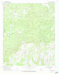
1970 Map of Center Point
USGS Topo · Published 1972About this map
The community of Center Point serves as the central hub of this 1970 survey, situated within a landscape defined by the winding Muddy Fork and the prominent elevation of Pea Ridge. The map documents a rural network of small family-named waterways, including Messer Creek, Bishop Creek, and Dawson Creek, which carve through the terrain of Howard County. Settlement patterns are anchored by long-standing landmarks like Wesley Chapel, New View Church, and the retreat at Camp Ebenezer. Genealogists will find significant detail in the various burial sites recorded across the township, such as Holly Creek Cemetery, Dawson Cemetery, and New Hope Cemetery. The economy of the era is evidenced by several Gravel Pits and a pipeline corridor, illustrating the rural industrial activity occurring alongside traditional agricultural land use in the northern reaches of the county.
Find a feature on this map
40 named features on this map. Tap any name to fly to it.
Don’t see what you’re looking for? This feature index may not catch every label — zoom into the map to look around manually.
Map Details
Editions of this 1970 Center Point Map
2 editions found
Other maps of this area

1906 · Caddo Gap
USGS Topo · 1:125,000

1913 · De Queen
USGS Topo · 1:125,000

1950 · Mcalester
USGS Topo · 1:250,000

1951 · Mineral Springs North
USGS Topo · 1:24,000

1951 · Nashville
USGS Topo · 1:24,000

1951 · Silver Ridge
USGS Topo · 1:24,000

1953 · Texarkana
USGS Topo · 1:250,000

1953 · El Dorado
USGS Topo · 1:250,000

1955 · Little Rock
USGS Topo · 1:250,000

1956 · Texarkana
USGS Topo · 1:250,000