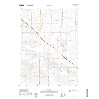
2018 Map of Center Point
USGS Topo · Published 2018About this map
Center Point sits as the central hub of this eastern Iowa landscape, where the Cedar River creates a complex network of wetlands and backwaters. The southern portion of the map is dominated by the wide river valley, containing features like Big Lewis Lake, Williams Lake, and the low-lying settlement of Lewis Bottoms. This geography contrasts with the northern uplands where Urbana is located, showing a transition from the riparian environment to the structured grid of agricultural roads. For those tracing local history, several burial grounds are documented, including Urbana Cem, Davis Cem, and Pleasant Ridge Cem. The presence of the 53rd Street Trl and various county highways like Co Hwy E16 indicates the modern transportation framework laid over the historic township lines of T85N and T86N.
Find a feature on this map
95 named features on this map. Tap any name to fly to it.
Don’t see what you’re looking for? This feature index may not catch every label — zoom into the map to look around manually.
Map Details
Editions of this 2018 Center Point Map
This is the sole edition of this map. No revisions or reprints were ever made.
Other maps of this area

1888 · Shellsburg
USGS Topo · 1:62,500

1888 · Marion
USGS Topo · 1:62,500

1889 · Marion
USGS Topo · 1:62,500

1889 · Shellsburg
USGS Topo · 1:62,500

1899 · Shellsburg
USGS Topo · 1:62,500

1903 · Winthrop
USGS Topo · 1:125,000

1959 · Dubuque
USGS Topo · 1:250,000

1961 · Dubuque
USGS Topo · 1:250,000

1962 · Dubuque
USGS Topo · 1:250,000
1967 · Cedar Rapids North
USGS Topo · 1:24,000