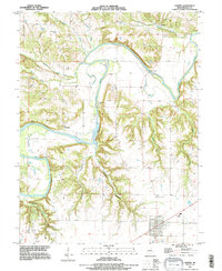
1991 Map of Center
USGS Topo · Published 1995About this map
The Salt River carves a deep valley through the Ralls County landscape, its meandering course defined by a complex network of ridges and deep drainage ravines like Griffin Hollow and Johnson Hollow. This 1990s revision, based on imagery updated by the U.S. Corps of Engineers, shows the community of Center at the southern edge, while the older riverside settlements of Spalding and Cincinnati sit at lower elevations near the water's edge.
Find a feature on this map
25 named features on this map. Tap any name to fly to it.
Don’t see what you’re looking for? This feature index may not catch every label — zoom into the map to look around manually.
Map Details
Editions of this 1991 Center Map
This is the sole edition of this map. No revisions or reprints were ever made.
Other maps of this area

1890 · Louisiana
USGS Topo · 1:125,000

1890 · Mexico
USGS Topo · 1:125,000

1903 · Palmyra
USGS Topo · 1:125,000

1932 · Hannibal
USGS Topo · 1:62,500

1936 · Hannibal
USGS Topo · 1:48,000

1943 · Vandalia
USGS Topo · 1:62,500

1945 · Hannibal
USGS Topo · 1:62,500

1945 · Perry
USGS Topo · 1:62,500

1945 · Vandalia
USGS Topo · 1:62,500

1948 · Quincy
USGS Topo · 1:250,000