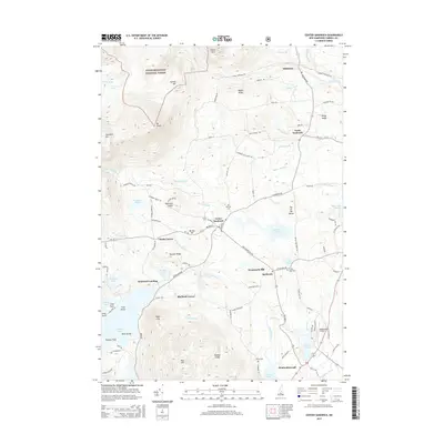
2015 Map of Center Sandwich
USGS Topo · Published 2015About this map
White Mountain National Forest dominates the northern reaches of this terrain, where peaks like Mt Israel and Whiteface overlook a landscape carved by the Bearcamp River and the Red Hill River. The village of Center Sandwich serves as a central hub, surrounded by smaller historical clusters such as Chicks Corner, North Sandwich, and Sandwich Landing on the shores of Squam Lake. This 2015 survey illustrates the enduring rural structure of Carroll County, with several cemeteries including Grove Cem and Mason Cem marking early family settlements and parish grounds. The road network, including RT-113 and Sandwich Notch Rd, connects the lowlands near Kusumpe Pond to the high ridges of Maple Ridge and Buzzell Ridge. This map provides a clear record of the intersection between established town centers and the protected wilderness areas that define the regional economy and layout.
Find a feature on this map
112 named features on this map. Tap any name to fly to it.
Don’t see what you’re looking for? This feature index may not catch every label — zoom into the map to look around manually.
Map Details
Editions of this 2015 Center Sandwich Map
This is the sole edition of this map. No revisions or reprints were ever made.
Other maps of this area

1909 · Winnepesaukee
USGS Topo · 1:62,500

1925 · Holderness
USGS Topo · 1:62,500

1927 · Holderness
USGS Topo · 1:62,500

1928 · Plymouth
USGS Topo · 1:62,500

1931 · Plymouth
USGS Topo · 1:62,500

1931 · Mt. Chocorua
USGS Topo · 1:62,500

1949 · Portland
USGS Topo · 1:250,000

1956 · Winnipesaukee
USGS Topo · 1:62,500

1956 · Holderness
USGS Topo · 1:62,500

1956 · Portland
USGS Topo · 1:250,000
Featured Places
- Moultonborough, NH
- Sandwich, NH
- Sandwich Landing, Sandwich
- Big Rock Corner, Sandwich
- Browns Point, Moultonborough