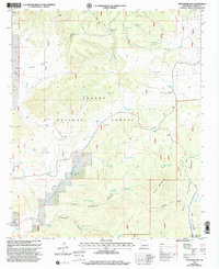
1999 Map of Centerfire Bog
USGS Topo · Published 2002About this map
Centerfire Bog lies at the heart of this high-elevation landscape, where the Apache National Forest meets the Gila National Forest. The map documents a critical network of water management features essential for ranching and forest operations in this arid region, including named wells, springs, and numerous livestock tanks such as Dead Horse Tank and Funderburg Tank. Topographical landmarks like Freeman Mountain and the wide Spur Lake Basin define the rugged character of Catron County. The presence of Rita Blanca Spring and Todd Browning Spring indicates the locations of vital natural water sources used long before modern infrastructure. This 1999 revision captures the intersection of conservation lands and the continuing legacy of western grazing, as seen in the scattered tanks and wells throughout Upper Cottonwood Canyon.
Find a feature on this map
50 named features on this map. Tap any name to fly to it.
Don’t see what you’re looking for? This feature index may not catch every label — zoom into the map to look around manually.
Map Details
Editions of this 1999 Centerfire Bog Map
This is the sole edition of this map. No revisions or reprints were ever made.
Other maps of this area

1915 · Reserve
USGS Topo · 1:125,000

1918 · Reserve
USGS Topo · 1:125,000

1954 · Clifton
USGS Topo · 1:250,000

1954 · Saint Johns
USGS Topo · 1:250,000

1957 · Clifton
USGS Topo · 1:250,000

1957 · Saint Johns
USGS Topo · 1:250,000

1958 · Clifton
USGS Topo · 1:250,000

1958 · Saint Johns
USGS Topo · 1:250,000

1962 · Clifton
USGS Topo · 1:250,000

1962 · Saint Johns
USGS Topo · 1:250,000