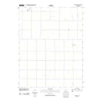
2009 Map of Centerview
USGS Topo · Published 2009About this map
The small community of Centerview is the primary settlement in this part of Edwards County, characterized by the expansive agricultural grid of western Kansas. The landscape is defined by the steady geometry of section lines and gravel paths, including Co RD 35, Co RD 36, and Co RD 42. A notable point for family researchers is the Trotter Cemetery, situated north of the main settlement. The map reveals the hydrology of the High Plains, with several intermittent drainage patterns cutting across the section lines, illustrating how local topography subtly influences the otherwise rigid survey grid. This 2009 representation provides a clear view of the rural infrastructure and land use in a region where the vastness of the plains is managed through a precise network of county roads and isolated homesteads.
Find a feature on this map
5 named features on this map. Tap any name to fly to it.
Don’t see what you’re looking for? This feature index may not catch every label — zoom into the map to look around manually.
Map Details
Editions of this 2009 Centerview Map
This is the sole edition of this map. No revisions or reprints were ever made.
Other maps of this area

1889 · Kinsley
USGS Topo · 1:125,000

1892 · Kinsley
USGS Topo · 1:125,000

1894 · Kinsley
USGS Topo · 1:125,000

1955 · Pratt
USGS Topo · 1:250,000

1959 · Pratt
USGS Topo · 1:250,000

1968 · Haviland NW
USGS Topo · 1:24,000

1969 · Greensburg NW
USGS Topo · 1:24,000
1969 · Greensburg NE
USGS Topo · 1:24,000
1972 · Fellsburg
USGS Topo · 1:24,000
1972 · Kinsley
USGS Topo · 1:24,000