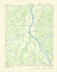
1936 Map of Centerville Landing
USGS Topo · Published 1936About this map
The Tennessee River corridor in West Tennessee is defined here by a series of riverside landings and ferry points just before the mid-century reservoir projects significantly altered the regional geography. This survey by Arthur E. Morgan and the Tennessee Valley Authority captures the river's winding path through Stewart and Henry counties, with the Big Sandy River feeding in from the south. The landscape is a mix of agricultural bottomlands and dense hollows, such as Mint Spring Hollow and Standing Rock Hollow, which shaped local settlement patterns. Notable river crossings and access points like Paris Landing and the Scott Fitzhugh Bridge served as vital transportation hubs. Community life is well-documented through numerous rural landmarks, including the Old Maple Grove Ch, Liberty Sch No 13, and the remote Swan Pond Swamp, providing a detailed look at the social fabric of the Henry County area during the late 1930s.
Find a feature on this map
91 named features on this map. Tap any name to fly to it.
Don’t see what you’re looking for? This feature index may not catch every label — zoom into the map to look around manually.
Map Details
Editions of this 1936 Centerville Landing Map
2 editions found
Other maps of this area

1936 · Poplar Creek
USGS Topo · 1:24,000

1936 · Buchanan
USGS Topo · 1:24,000

1936 · Tharpe
USGS Topo · 1:24,000

1936 · New Concord
USGS Topo · 1:24,000

1936 · McKinnon
USGS Topo · 1:24,000

1936 · Hamlin
USGS Topo · 1:24,000

1936 · Centerville Landing
USGS Topo · 1:24,000

1936 · Standing Rock
USGS Topo · 1:24,000

1936 · Springville
USGS Topo · 1:24,000

1938 · Springville
USGS Topo · 1:24,000