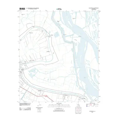
2012 Map of Centerville
USGS Topo · Published 2012About this map
Bayou Teche defines the cultural and economic landscape of this portion of St. Mary Parish, winding past the historic seat of Franklin and smaller settlements like Garden City and Centerville. The map documents a landscape of legacy plantations and agricultural tracts, evidenced by family-named locations such as Oaklawn, Caffery, and Sterling. The area is deeply marked by its water-dependent industry and infrastructure, from the Oaklawn Canal and West Protection Levee to the numerous spans crossing the bayou, including the Sterling Bridge and Willow Street Bridge. Local history and genealogy are anchored by several distinct burial grounds, such as Israelite Cem, Palo Alto Cem, and Oaklawn Cem. Beyond the residential corridors, the map traces the heavy industrial footprint of the energy sector with the Franklin Oil Field and South Myette Point Gas Field, showing how resource extraction coexists with the intricate bayou network and marshes leading toward Duck Lake.
Find a feature on this map
65 named features on this map. Tap any name to fly to it.
Don’t see what you’re looking for? This feature index may not catch every label — zoom into the map to look around manually.
Map Details
Editions of this 2012 Centerville Map
This is the sole edition of this map. No revisions or reprints were ever made.
Other maps of this area

1937 · Bayou Sale
USGS Topo · 1:62,500

1937 · Jeanerette
USGS Topo · 1:62,500

1941 · Belle Isle
USGS Topo · 1:62,500

1945 · New Orleans
USGS Topo · 1:250,000

1948 · Foster
USGS Topo · 1:62,500

1954 · Jeanerette
USGS Topo · 1:62,500

1954 · Belle Isle
USGS Topo · 1:62,500

1957 · Bayou Sale
USGS Topo · 1:62,500

1959 · Foster
USGS Topo · 1:62,500

1963 · New Orleans
USGS Topo · 1:250,000